Gera Lario-San Bartolomeo-Monti Vercana
Advanced L2 - Porto di Gera Lario – San Bartolomeo – Monti Vercana
DEPARTURE/ARRIVAL
From: Gera Lario
To: Gera Lario
TYPE/PERIOD
E-mtb
Autumn / Spring / Summer
Duration/Length
4 hours
32 km
CHANGE IN ALTITUDE
Uphill: 1312.99 m
DIFFICULTY
Advanced

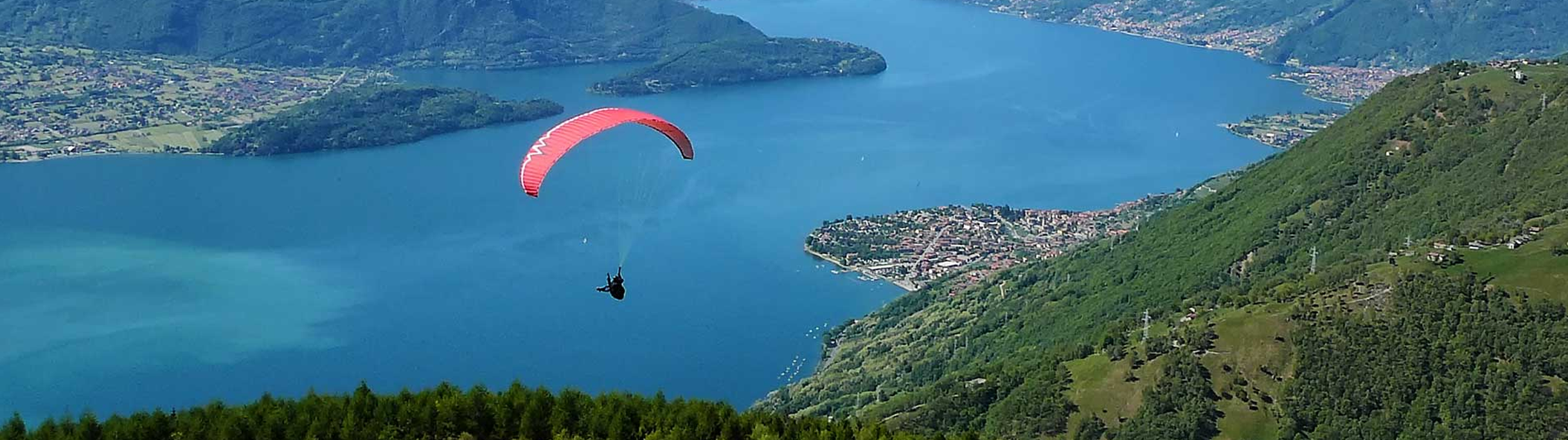
This mountain bike tour starts in the small village of Gera Lario, located on the shores of Lake Como. You can park your car in the rest areas near the lakefront, not far from the Castello di San Giorgio and the Torre Nuova. The first section of the route is uphill on a state road. You continue towards the Baita del Vikingo until you reach an altitude of about 1,000 meters. The climb is quite challenging but on a paved road and offers stunning views of Lake Como, the Orobie Mountains and the Valtellina. At about halfway up the climb, you reach Fordeccia, where there is a belvedere with a panoramic view of the valley. From here, you take the Via dei Monti Lariani, a trail that crosses the Gera Lario plateau. Caution is needed to cross the Sorico torrent where the descent is very steep and technical: the bike will have to be carried by hand. From here, you continue in the direction of Dalco and Montalto. From this small village, overlooking Monte Legnone, you take the trail that from the Via dei Monti Lariani continues in the direction of Pomè and Tabbiadello halfway up with continuous “up and downs” and several fords of torrents. The climb from the Valle del San Vincenzo is just as challenging, with short and vertical slopes from the riverbed. Care is needed on the descent towards the Valle del San Vincenzo. The iconic bridge is iconic; from here a short climb will force you to push the bicycle, until you reach the line of the coastal trail. After crossing the torrents of the Valle del Baito and the Valle dell’Acquafresca, you reach Tabbiadello, where the descent to Gera Lario begins. The route is easy and panoramic on mountain roads and allows you to admire Lake Como from a different perspective. Then you descend quickly towards Vercana and Trezzone to return to the lakefront of Gera Lario passing by the Chiesa di Santa Maria delle Grazie. Water can be refilled along the route. E-bike ascent is recommended. Without the assistance of the engine, this route can be extremely challenging in the steepest sections.


Cities crossed by the itinerary

Watch the itinerary video

Fotogallery

Vista sul sentiero piazza lunga
Via monti lariani

Point of Interest

Itinerary Data

hedaer

A new cycle network has been created in the Upper Lake Como area. There are 23 routes in two large areas along the lake's shores, for a total of 380 kilometers. Two routes are for beginners, 10 for intermediates, 8 for advanced cyclists, and 3 for experts. The difficulty scale and route tracking were verified by CAI experts, and an international evaluation standard was adopted in agreement with the Lombardy Region.


Along the routes, there are many panoramic points where you can admire the stunning beauty of Lake Como. The app provides all the information you need to safely navigate the routes, including directions to equipped areas, places of art and culture to visit, and events scheduled in the towns along the chosen route. You can also watch videos of the best panoramic views.


THE CYCLE ROUTES OF THE WESTERN NORTH LAKE COMO - There are 8 new routes at mid-mountain and high altitude, for a total length of 134 kilometers. The routes connect to existing connections between mountain towns and lakeside towns, where there is already a cycle path. The routes start in Sorico and pass through Montemezzo, Vercana, Trezzone, Livo, Peglio, Dosso del Liro, Gravedona ed Uniti, Stazzona, Dongo, Garzeno, Pianello del Lario, Musso, and end in Cremia.


THE CYCLE ROUTES IN THE VALSASSINA - There are 15 routes that allow you to climb from the lake to the Valsassina and Valvarrone, taking advantage of the trails on Mount Legnoncino; the loop circuits in the North Valsassina; the connections with the Valsassina cycle path; and the routes of the Val d'Esino.


WHAT ARE INTERNAL AREAS AND THE "UPPER LAKE COMO AND VALLI DEL LARIO" STRATEGY? - The "North Lake Como and Valli del Lario" Area Strategy was launched in 2018 as part of the National Strategy for Internal Areas 2014/2020. It involved 31 municipalities in the Valsassina, Valvarrone, Val d'Esino, and Riviera (Lecco) communities and the Valli del Lario and Ceresio communities (Como). The National Strategy for Internal Areas (SNAI) is a strategic plan designed to enhance and develop internal areas, which are often characterized by challenges such as depopulation, lack of services, and fewer economic opportunities. The goal is to promote the sustainable development of these areas by investing in infrastructure, services, the local economy, and the preservation of cultural and natural resources. The "Upper Lake Como and Valli del Lario" Area Strategy, implemented in the period 2018/2023, has made it possible to implement 31 projects for a total of 20 million euros, of which 5,285,000 euros were used to promote interventions to recover and enhance the heritage and to strengthen the cycle and hiking routes between the lake and the valleys.

Install app

GO
What is a PWA? Progressive Web Apps are a hybrid of mobile app and Web site: it is a technology that runs on the browser and does not require downloads from the app store, which contains Web pages just like a site. Through the install command on the browser you can create a quick link on your smartphone.